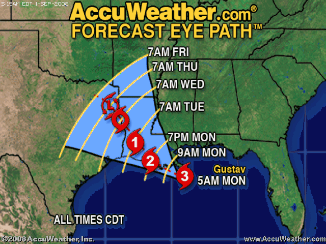
die ich gepostet hatte, betreffen nicht die Futures, sondern den "Eye-Path" von Gustav und seine voraussichtliche Stärke beim Landfall (zurzeit erwartet: 3 oder leicht stärker). Der Landfall wird heute kurz nach US-Börsenbeginn erwartet, vermutlich zwischen 15:00 und 17:00 Uhr MEZ = 8 - 10 a.m. CDT. Da dürften sich also buchstäblich einige Turbulenzen zur Börseneröffnung ergeben.
Bei Katrina kamen die Probleme nicht sofort, sondern erst später, als New Orleans nach einem Dammbruch langsam voll Wasser lief. D.h. selbst wenn bei Gustav auf den ersten Blick wenig passiert zu sein scheint, kann es immer noch ein übles Ende mit Überflutungen geben.
Der Landfall wird nach bisherigem Eye-Path ca. 50 km westlich vom Stadtzentrum von N.O. als Kategorie 3 Sturm (evtl. auch noch etwas stärker) erfolgen. Hurrikane haben allerdings die Tendenz, nach Osten abzudriften, so dass der Sturm auch mitten durch die Stadt ziehen könnte.
ACCUWEATHER (erschienen vor 1 Std.)
Gustav Making Landfall This MorningGustav is a Category 3 hurricane with winds of 115 mph. At 4:00 a.m. CDT, the hurricane was located near 28.44 north, 89.5 west. That is 115 miles south to southeast of New Orleans, Louisiana. Gustav is moving northwest at 16 mph. At this speed and course Gustav should make landfall between 8:00 a.m. and 10:00 a.m., CDT, Monday along the southern coast of Louisiana, most likely in Terrebonne or Lafourche parish. This is just south of Houma, Louisiana.
A hurricane warning is in effect from just east of High Island, Texas, to the Alabama/Mississippi border, including New Orleans and Lake Pontchartrain. A tropical storm warning is in effect east of the Alabama/Mississippi border to the Ochlockonee River.
Hurricane-force winds extend 70 miles from the storm center, with tropical storm-force winds extending 220 miles from the center. The central pressure as measured by a NOAA research aircraft is 954 mb, or 28.17 inches. Gustav might still intensify some before landfall on Monday. However, chances of reaching Category 4 strength are diminishing.
Tropical storm-force winds have already occurred in the New Orleans area and will continue to increase through the morning on Monday. Hurricane conditions will develop on the Louisiana coast by early on Monday morning and are possible in New Orleans by midmorning. A storm surge of 10-20 feet is expected on the Louisiana coast near and just east of where the center makes landfall. A storm surge near 10 feet is expected on Lake Borgne just east of New Orleans. Again, it appears that Terrebonne and Lafourche parishes will experience the highest storm surge. Rainfall totals of 10-20 inches of rain are expected over parts of Louisiana and southern Mississippi. Similar rainfall totals might occur over parts of northeastern and East Texas if Gustav ends up stalling.
Although Louisiana is bracing for the worst effects from Gustav, residents from the upper Texas coast to the western Florida Panhandle should pay close attention for any shifts in the track of Gustav. Once inland, Gustav is expected to slow significantly (Das machen alle Hurrikane über Land - A.L.]. This could cause major flooding on Tuesday and Wednesday across inland Louisiana and northeast and parts of eastern Texas.
hurricane.accuweather.com/hurricane/...aveler=0&basin=atlantic
Hier der aktuelle Eye-Path von Accuweather: (Verkleinert auf 87%)