







Jetzt anmelden und diskutieren
Registrieren
Login

 Aufrufe: 214
 Audio
Audio
 Teilen

Program Summary
Assay Highlights
Alkane Managing Director & CEO, Nic Earner, said:
“We are encouraged by the results coming from our near mine extension programs at Björkdal. The positive results indicate that the mineral system is still strong and open at depth. These results, together with the new resource at Storheden, support our confidence in the potential to increase production in addition to the longevity of the operation.”
Björkdal Gold Mine
Alkane Resources Ltd 100%
The Björkdal Gold Mine is located on the eastern margin of the prolific Skellefte Belt in northern Sweden, approximately 28 km northwest of Skellefteå and 750 km north of Stockholm (Figure 1).
The deposit was discovered in 1983 by Terra Mining AB through a glacial till sampling program that identified anomalous gold values. Follow-up exploration led to the discovery of gold mineralisation in bedrock in 1985, with resource definition drilling commencing in 1986. Concurrent metallurgical test work and feasibility studies delivered positive results, paving the way for the commencement of mining operations in July 1988.
Since production began, Björkdal has undergone several changes in ownership while continuing to operate as a significant gold-producing asset. Most recently, the operation became wholly owned by Alkane Resources following its merger with Mandalay Resources in August 2025.
Production is supported by the 1.4 Mtpa processing plant, which has been progressively upgraded since commissioning. Current ore feed is sourced from underground mining operations and surface low-grade stockpiles.
Since the start of production in 1988, the Björkdal Mine has produced approximately 1.69 million ounces of gold. Continued exploration success has delivered growth in both Mineral Resources and Ore Reserves, with the current Ore Reserve reported, as of 30 June 2025, of 13.05 Mt grading 1.29g/t gold (ASX announcement 15 October 2025 titled ‘Björkdal Resources and Reserves Statement FY25’)
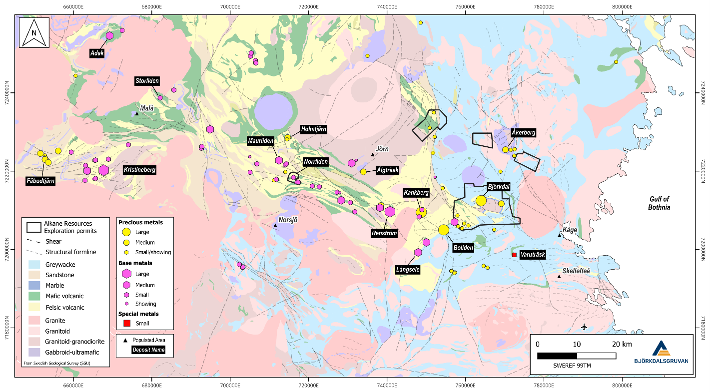
Figure 1: Regional map showing the location of Björkdalsgruvan relative to the broader Skellefte Belt, highlighting known base and precious metal occurrences (SWEREF 99TM).
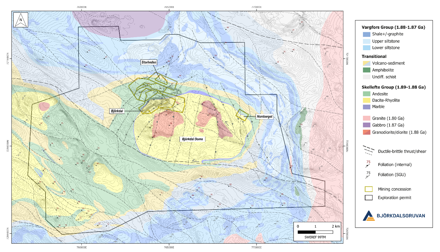
Figure 2: Regional geological map showing the locations of the three main deposits in the Björkdal area and contiguous exploration permits (SWEREF 99TM).
Deposit Geology
The Björkdal Gold Mine is located in the eastern part of the Paleoproterozoic Skellefte District in northern Sweden. The Skellefte District constitutes a 1.89–1.88 Ga volcanic arc and hosts numerous volcanic massive sulphide (VMS) and lode gold deposits (Figure 1).
Mineralisation at Björkdal occurs primarily as free milling gold and is hosted within centimetre- to meter-wide, subvertical quartz veins, predominantly beneath a marble horizon within a complex sequence of volcano-sedimentary rocks belonging to the Upper and Lower Skellefte Groups (Figure 2). The mineralised system plunges eastward and northward (mine grid), forming a 30–60 metre thick zone of sheeted quartz veins containing gold mineralisation (Figure 4).
The principal vein set strikes east-west (070–090° in mine grid coordinates) and represents the primary target for underground mining both above and below the marble horizon. Additional subordinate vein sets occur at varying orientations and may also host economically significant gold mineralisation.
Vein geometry and distribution are strongly influenced by shearing, thrusting and folding. Variations in vein orientation (Figure 3), mineralogy, wall-rock alteration and fluid inclusion characteristics indicate multiple phases of veining and mineralising fluid activity.
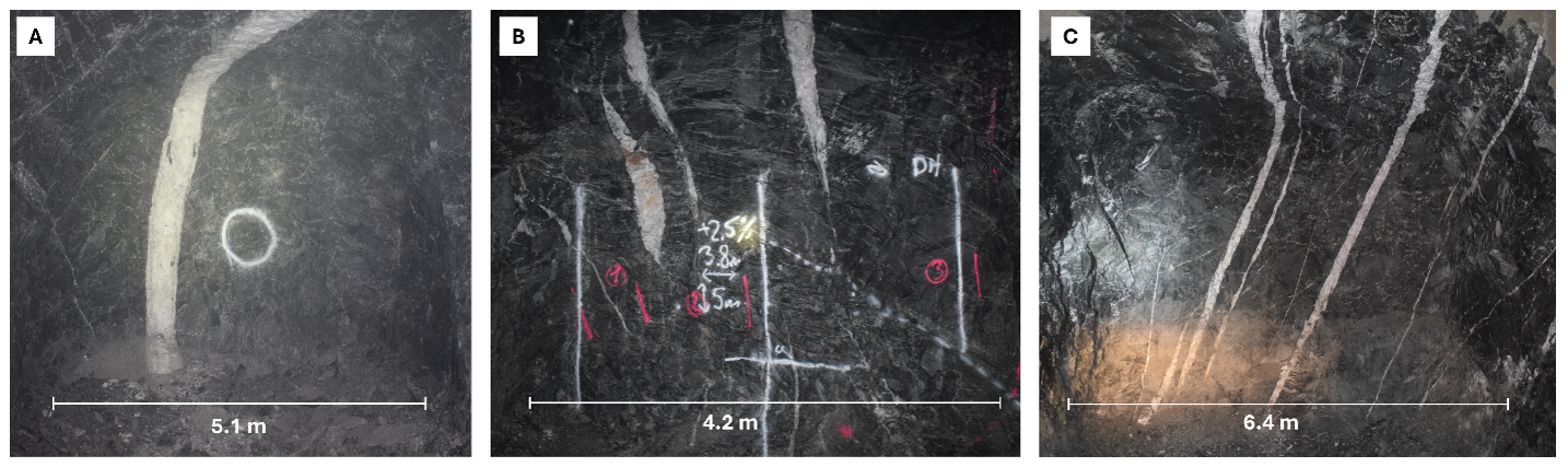
Figure 3: Typical auriferous quartz veining observed at Björkdal. (A) Main Zone. (B) Lake Zone. (C) Lake Zone Above.
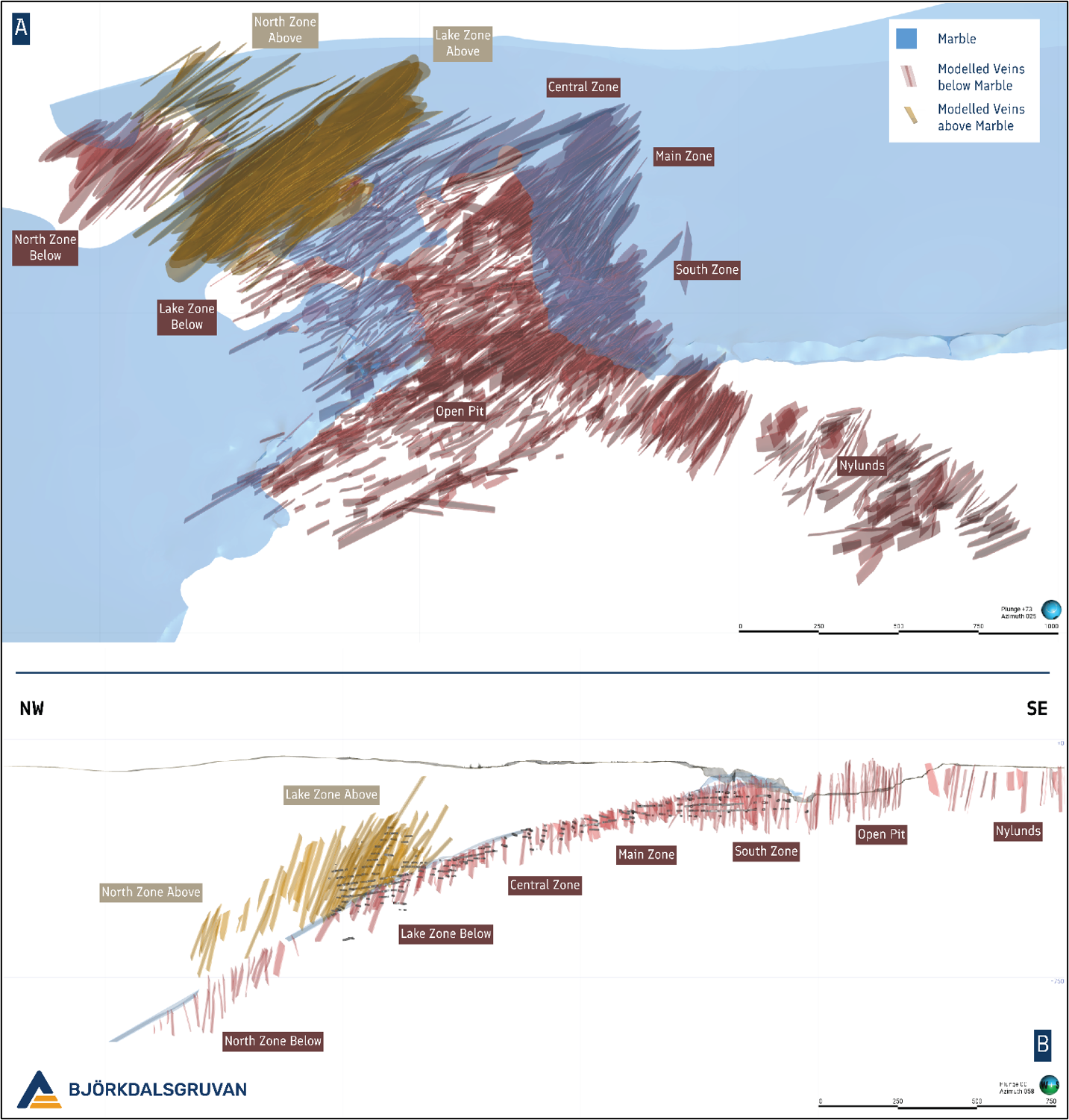
Figure 4: (A) Oblique view looking down and to the NE (Mine Grid) displaying known auriferous quartz veining at Björkdal. (B) Cross section ± 30 metres along the Björkdal deposit looking to the NE (Mine Grid).
Drilling Results
Since the previous release, 29 growth and infill drill holes have been completed, totalling 15,568m of diamond drilling. Drilling was focused on two target areas within the underground mine, the Eastern and Northern Extension (Figure 5). Both target areas are situated stratigraphically below the marble unit that extends throughout the mine area.
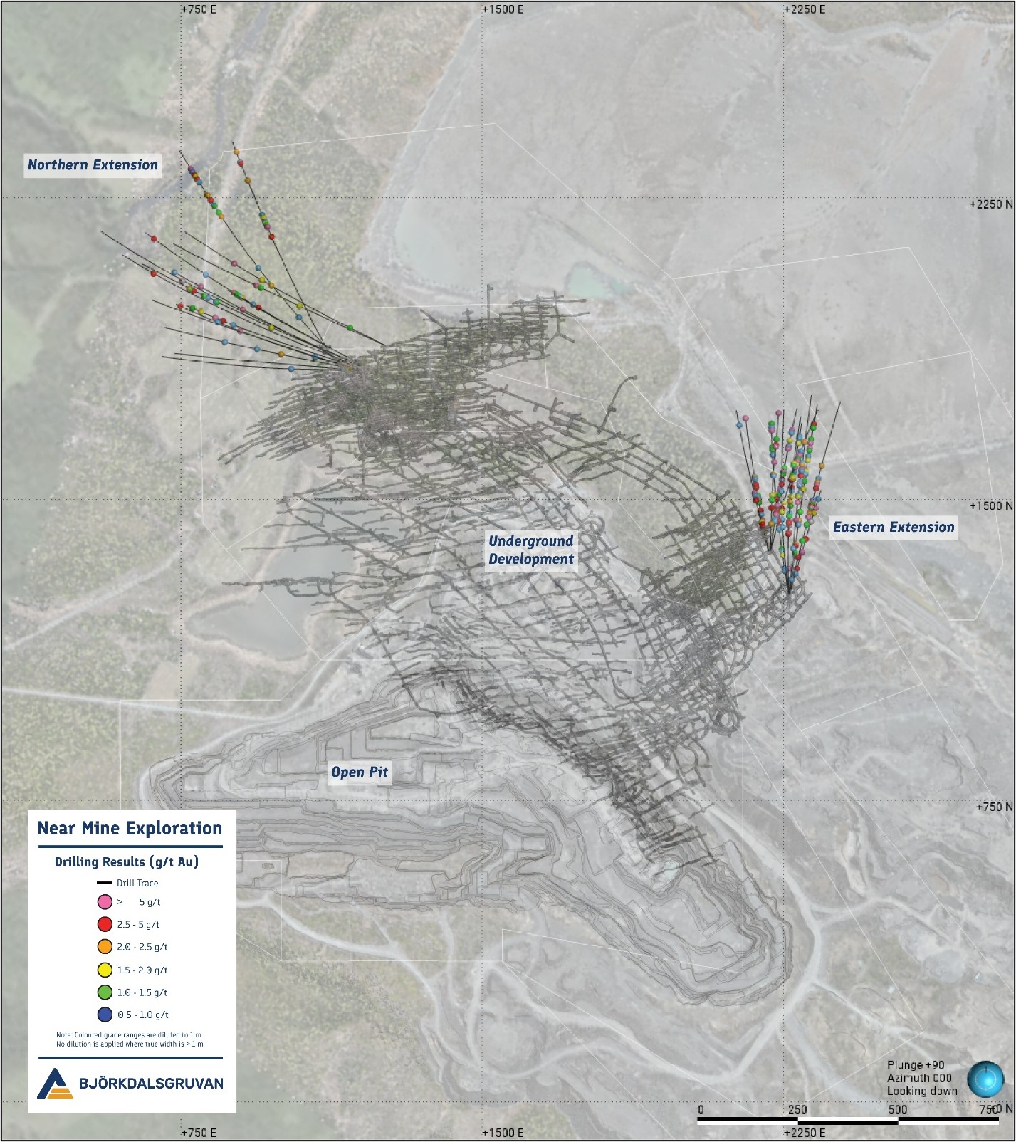
Figure 5: Mine Scale overview showing the location of the most recent drilling in relation to current underground development (Mine Grid).
Eastern Extension
Thirteen holes have been drilled along the eastern flank of the mine since June 2025, totalling 6,304 m with an average hole depth of 485 m. The program was completed in two phases of infill and extensional drilling, targeting strike and depth extensions of veining within the Main Zone of the underground mine. A total of 169 ore-grade intercepts have been identified within the target zone, including the best result from drillhole MU25-030, which returned 86.1 g/t gold over 1.25 m (ETW 0.80 m). The program also delivered the deepest intercept recorded at the mine to date, with drillhole MU25-021 returning 3.5 g/t gold over 3.20 m (ETW 2.45 m) at -976 RL (-762 m elevation) (Figure 6).
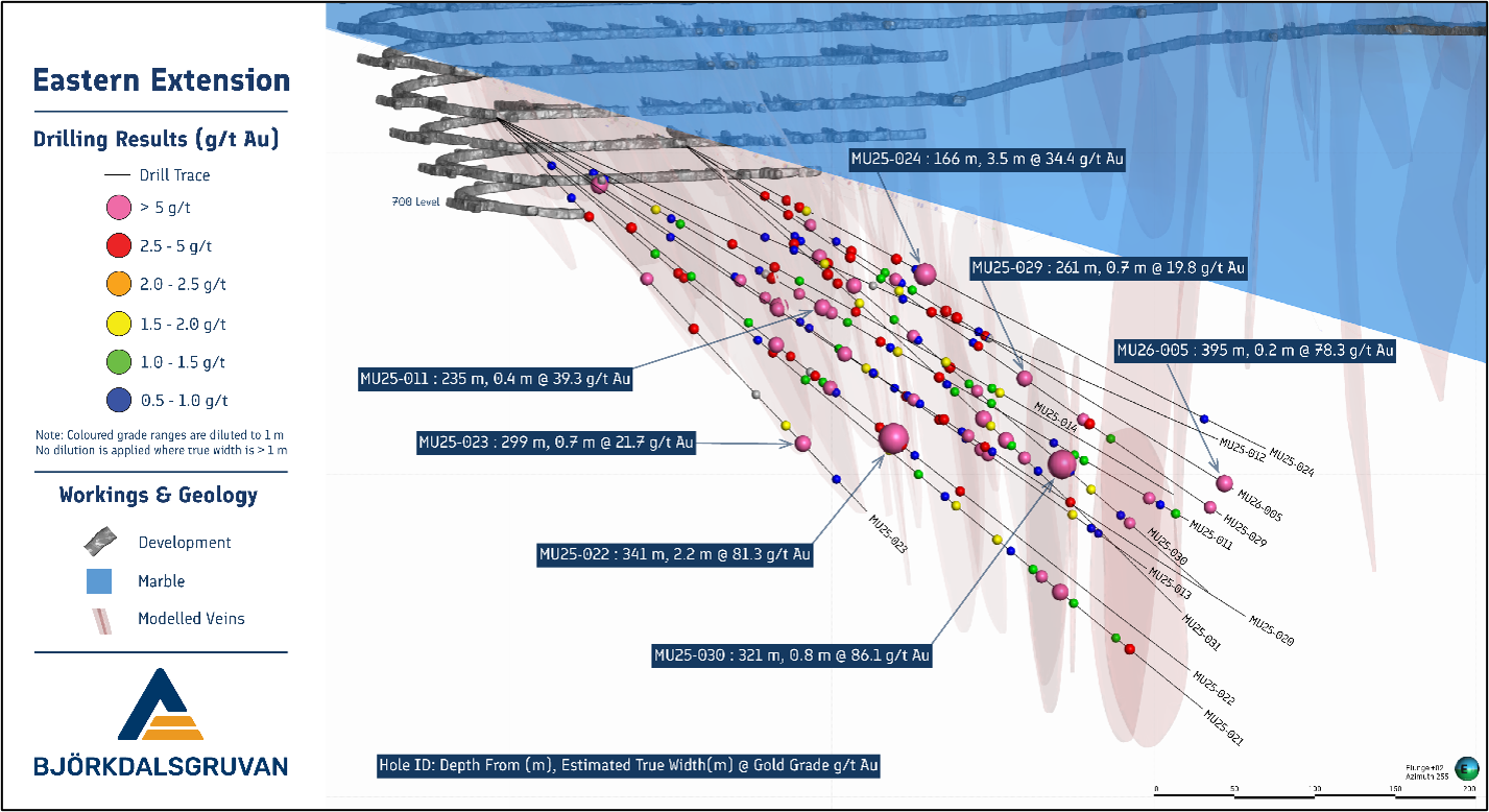
Figure 6: Oblique view to the WSW highlighting results from the most recent drilling campaign along the eastern flank of the underground mine.
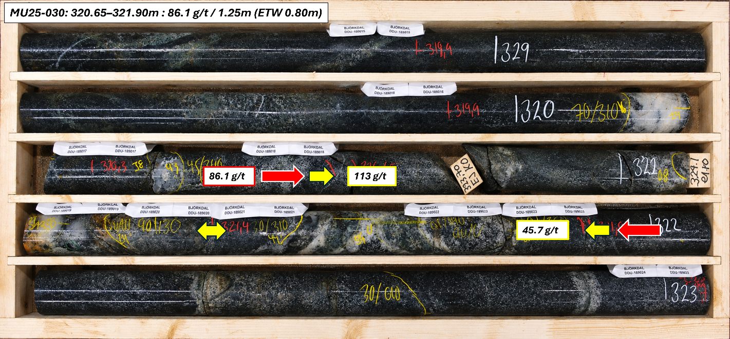
Figure 7: Core tray photograph from MU25-030, where the highest-grade interval of the drill program was intersected.
Northern Extension
Sixteen holes were drilled within the Northern Extension of the underground mine since June 2025, totalling 9,264 m, with an average hole depth of 580 m. Building on the success of previous drilling campaigns, the program was designed to improve the understanding of vein morphology and structural controls on mineralisation, while testing the northern and western extensions of known veining.
The program successfully confirmed previously identified vein swarms and further enhanced confidence in the geological interpretation of the area. Assessment of the western extent of the target zone was constrained by the availability of underground drill platforms; however, the information collected has enabled the development of a more robust structural model, which will support future targeting and resource growth within the Northern Extension. A total of 68 ore-grade intercepts have been identified within the target zone, including the best result from drillhole MU26-002, which returned 31.5 g/t gold over 0.85 m (ETW 0.22 m). Drilling has confirmed mineralised veins up to approximately 600 m from existing underground development (Figure 8).
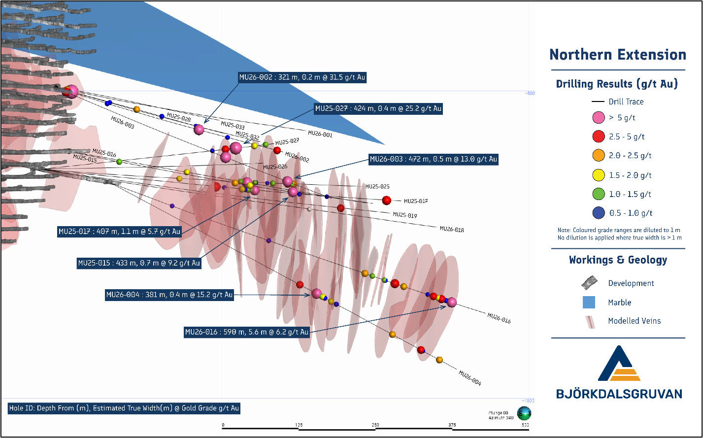
Figure 8: Oblique view to the SW highlighting results from the most recent drilling campaign in the Northern extension of the underground mine.
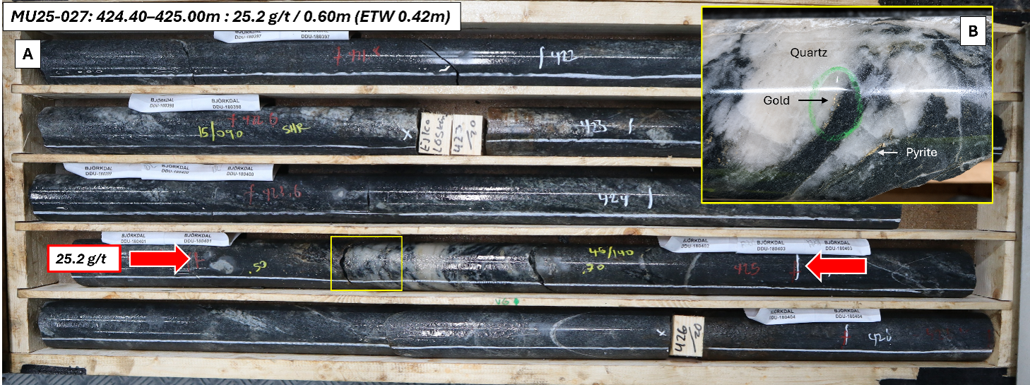
Figure 9: Drill core photos from MU25-027 showing an intercept grading 25.2 g/t gold over 0.60 m (ETW 0.42 m) (A) and a close-up of mineralised quartz vein (B).
Future Plans
Mineralisation remains open at depth and along strike in both the Northern Extension and Eastern Extension target areas. In FY27, underground drilling will continue in staged programs of infill and extension drilling aimed at improving geological confidence and testing continuity of mineralisation.
At the Northern Extension, drilling will continue to test both depth and along-strike continuity, with western extension drilling to be supported by the establishment of a dedicated underground drill platform. This will enable improved drill orientations and reduce scheduling conflicts between drilling and mining activities.
At the Eastern Extension, mineralisation remains open at depth and along strike to the east. Future drilling will focus on step-out extensional testing to assess the continuity of known vein swarms and refine the structural controls on mineralisation in this area.
This document has been authorised for release to the market by Nic Earner, Managing Director and CEO.
ABOUT ALKANE ‐ www.alkres.com ‐ ASX:ALK | TSX: ALK | OTCQX: ALKRY
Alkane (ASX:ALK; TSX:ALK; OTCQX:ALKEF) is an Australia-based gold and antimony producer with a portfolio of three operating mines across Australia and Sweden. The Company has a strong balance sheet and is positioned for further growth.
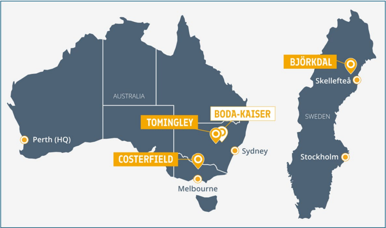
Alkane’s wholly owned producing assets are the Tomingley open pit and underground gold mine southwest of Dubbo in Central West New South Wales, the Costerfield gold and antimony underground mining operation northeast of Heathcote in Central Victoria, and the Björkdal underground gold mine northwest of Skellefteå in Sweden (approximately 750 km north of Stockholm). Ongoing near-mine regional exploration continues to grow resources at all three operations.
Alkane also owns the very large gold-copper porphyry Boda-Kaiser Project in Central West New South Wales and has outlined an economic development pathway in a Scoping Study. The Company has ongoing exploration within the surrounding Northern Molong Porphyry Project and is confident of further enhancing eastern Australia’s reputation as a significant gold, copper and antimony production region.
Competent / Qualified Persons Statement
Certain information in this announcement relating to Exploration Results has been previously released to the ASX. Alkane confirms that it is not aware of any new information or data that materially affects the information included in those market announcements and that all material assumptions and technical parameters underpinning the estimates and Exploration Results in those announcements continue to apply and have not materially changed.
The information in this report that relates to the Costerfield Exploration Results is based on, and fairly represents, information compiled and verified by Mr Chris Davis. Mr Davis is a Chartered Professional (Geology) of the Australasian Institute of Mining and Metallurgy (MAusIMM CP(Geo)) and a Member of the Australian Institute of Geoscientists (MAIG).
Mr Davis has sufficient experience that is relevant to the style of mineralisation and type of deposit under consideration and to the activity being undertaken to qualify as a Competent Person as defined in the 2012 Edition of the “Australian Code for Reporting of Exploration Results, Mineral Resources, and Ore Reserves” (JORC Code).
For the purposes of National Instrument 43-101 – Standards of Disclosure for Mineral Projects (‘NI 43-101’), the scientific and technical information contained in this announcement relating to the Costerfield Exploration Results has been prepared under the supervision of, and approved by, Mr Chris Davis, who is a “qualified person” as defined in NI 43-101. Mr Davis is employed by Alkane as Chief Geologist and, as an employee of Alkane, is not considered independent of Alkane within the meaning of NI 43-101.
Mr Davis consents to the inclusion in this report of the matters based on his information in the form and context in which they appear.
Cautionary Note Regarding Forward-Looking Information and Statements
This announcement contains certain forward-looking information and forward-looking statements within the meaning of applicable securities legislation and may include future-oriented financial information or financial outlook information (collectively Forward-Looking Information). Actual results and outcomes may vary materially from the amounts set out in any Forward-Looking Information. As well, Forward-Looking Information may relate to: future outlook and anticipated events; expectations regarding exploration potential; production capabilities and future financial or operating performance, including AISC, investment returns, margins and share price performance; production and cost guidance and the timing thereof; issuing updated resources and reserves estimate and the timing thereof; the potential of Alkane to meet industry targets, public profile and expectations; and future plans, projections, objectives, estimates and forecasts and the timing related thereto.
Forward-Looking Information is generally identified by the use of words like "will", "create", "enhance", "improve", "potential", "expect", "upside", "growth" and similar expressions and phrases or statements that certain actions, events or results "may", "could", or "should", or the negative connotation of such terms, are intended to identify Forward-Looking Information.
Although Alkane believes that the expectations reflected in the Forward-Looking Information are reasonable, undue reliance should not be placed on Forward-Looking Information since no assurance can be provided that such expectations will prove to be correct. Forward-Looking Information is based on information available at the time those statements are made and/or good faith belief of the officers and directors of Alkane as of that time with respect to future events and are subject to risks and uncertainties that could cause actual results to differ materially from those expressed in or suggested by the Forward-Looking Information. Forward-Looking Information involves numerous risks and uncertainties. Such factors include, without limitation: risks relating to changes in the gold and antimony price.
Forward-Looking Information is designed to help readers understand Alkane’s views as of that time with respect to future events and speak only as of the date they are made. Except as required by applicable law, Alkane assumes no obligation to update or to publicly announce the results of any change to any forward-looking statement contained or incorporated by reference herein to reflect actual results, future events or developments, changes in assumptions or changes in other factors affecting the Forward-looking Information. If Alkane updates any one or more forward-looking statements, no inference should be drawn that the company will make additional updates with respect to those or other Forward-looking Information. All Forward-Looking Information contained in this announcement is expressly qualified in its entirety by this cautionary statement.
Disclaimer
Alkane has prepared this announcement based on information available to it. No representation or warranty, express or implied, is made as to the fairness, accuracy, completeness or correctness of the information, opinions or conclusions contained in this announcement. To the maximum extent permitted by law, none of Alkane, its directors, officers, employees, associates, advisers and agents, nor any other person accepts any liability, including, without limitation, any liability arising from fault or negligence on the part of any of them or any other person, for any loss arising from the use of this announcement or its contents or otherwise arising in connection with it.
This announcement is not an offer, invitation, solicitation, or other recommendation with respect to the subscription for, purchase or sale of any security, and neither this announcement nor anything in it shall form the basis of any contract or commitment whatsoever.
APPENDIX 1 – Tabulated Drilling Results
Significant intercepts from Near Mine Exploration drilling program at Björkdal
Drill hole collar details from Near Mine Exploration drilling program at Björkdal:
APPENDIX 2
JORC Code, 2012 Edition – Table 1 Report – Björkdal Gold Mine
Section 1 Sampling Techniques and Data
(Criteria in this section apply to all succeeding sections.)
Section 2 Reporting of Exploration Results
(Criteria listed in the preceding section also apply to this section.)
CONTACT: NIC EARNER, MANAGING DIRECTOR & CEO, ALKANE RESOURCES LTD, TEL +61 8 9227 5677
INVESTORS & MEDIA: NATALIE CHAPMAN, CORPORATE COMMUNICATIONS MANAGER, TEL +61 418 642 556
Images accompanying this announcement are available at
https://www.globenewswire.com/NewsRoom/AttachmentNg/92af8b75-780a-4f19-acd6-a0ee0bdbb3fd
https://www.globenewswire.com/NewsRoom/AttachmentNg/1e1786c7-59b1-48c9-95b4-7791e637a51b
https://www.globenewswire.com/NewsRoom/AttachmentNg/eef6250f-72c7-493a-a897-8221f7725ca0
https://www.globenewswire.com/NewsRoom/AttachmentNg/b56737cc-49e3-46d1-be14-9f9fbde05437
https://www.globenewswire.com/NewsRoom/AttachmentNg/681739ed-b8ba-45db-9e26-d809e8a06211
https://www.globenewswire.com/NewsRoom/AttachmentNg/fdf4a701-51d4-4d49-84c5-ae78e4f50bf1
https://www.globenewswire.com/NewsRoom/AttachmentNg/cc71f3ac-e0b8-47d1-8b2c-48bb9fb54754
https://www.globenewswire.com/NewsRoom/AttachmentNg/f070f84e-199d-4ff1-aa59-2c80647151ce
https://www.globenewswire.com/NewsRoom/AttachmentNg/8e68e99d-8ac1-473a-84da-f3e5afac1f2f
https://www.globenewswire.com/NewsRoom/AttachmentNg/cc18874d-f5cf-4dbe-b630-a6679429a4f8
Hinweis: ARIVA.DE veröffentlicht in dieser Rubrik Analysen, Kolumnen und Nachrichten aus verschiedenen Quellen. Die ARIVA.DE AG ist nicht verantwortlich für Inhalte, die erkennbar von Dritten in den „News“-Bereich dieser Webseite eingestellt worden sind, und macht sich diese nicht zu Eigen. Diese Inhalte sind insbesondere durch eine entsprechende „von“-Kennzeichnung unterhalb der Artikelüberschrift und/oder durch den Link „Um den vollständigen Artikel zu lesen, klicken Sie bitte hier.“ erkennbar; verantwortlich für diese Inhalte ist allein der genannte Dritte.