




Costerfield – True Blue Exploration Update

GlobeNewswire  | 
aufrufe Aufrufe: 231
A-
A+
Lesemodus
playAudio
playTeilen
Schriftzug
- pixabay.com

PERTH, Australia, July 05, 2026 (GLOBE NEWSWIRE) -- Alkane Resources Limited (ASX: ALK; TSX: ALK; OTCQX: ALKRY) (‘Alkane’ or ‘the Company’) is pleased to announce the latest exploration results for extension and infill drilling of the True Blue deposit, located 2 km west of the active underground workings at its Costerfield Operation in central Victoria, Australia.

Program Summary

  • An additional 33 holes targeting the Freeman veining within the True Blue deposit have been drilled since Alkane’s previous update (ASX announcement 15 October 2025 titled ‘Costerfield Resource and Reserve Statement).
  • The new drilling predominantly targeted infill of the upper portion of the deposit and has significantly increased confidence in understanding the vein geometry and grade-controlling structures.
  • The higher resolution granted by the infill drilling indicates there is further veining complexity that serves to break-up a previously interpreted high-grade panel.
  • Current and future exploration drilling will target along-strike repetitions of mineralisation at True Blue both to the north and south, and investigate the link between it and the West Costerfield prospect.

True Blue Assay Highlights

  • From Freeman (700) Vein:
    • 57.6g/t gold and 25.4% antimony over 0.25m (ETW 0.17m) in TB055
    • 20.9g/t gold and 19.5% antimony over 0.31m (ETW 0.22m) in TB057
    • 4.3g/t gold and 6.4% antimony over 0.8m (ETW 0.63m) in TB080
    • 30.1g/t gold and 14.8% antimony over 0.27m (ETW 0.17m) in TB065

  • From associated veins

    • 84.1g/t gold and 15.4% antimony over 0.48m (ETW 0.36m) in TB084 (702 splay)
    • 17.9g/t gold and 1.7% antimony over 3.2m (ETW 1.4m) in TB053 (705 vein)
    • 19.3g/t gold and 29.3% antimony over 0.22m (ETW 0.16m) in TB079
    • 11.2g/t gold and 5.7% antimony over 0.77m (ETW 0.54m) in TB055

Werte aus dem Artikel:

Alkane Managing Director & CEO, Nic Earner, said:

“The infill drilling of True Blue gives us the geological confidence needed to proceed with our plans for development of the deposit. The geological context gained from the drilling has also enhanced the model for further targeting along the True Blue Corridor. True Blue is certainly more complex than our original estimates, we are encouraged by the progress made and excited by the targets yet to be tested.”

Costerfield Gold-Antimony Field
Alkane Resources Ltd 100%

The Costerfield gold-antimony deposit was discovered in 1861, antimony having been already identified in the district as early as 1853 as prospectors attracted to the McIvor (Heathcote) alluvial gold rush began to explore the surrounding hills for the primary deposits. Several lodes along a 3km corridor were rapidly opened up with the bulk of historical production coming from leases at the northern end of the field; the Costerfield (Main), Bombay and Minerva mines. Production from these mines primarily took place in two phases, between 1861-1883 and 1903-1924, and a short-lived attempt at redeveloping the mine occurred between 1933-1939.

Modern mining has been continuous since 2006, when Australian Gold Development commenced underground operations at Augusta, at the southern end of the field. AGD’s Costerfield operation was purchased by Mandalay Resources in 2010, and extraction of the vertically continuous vein system has progressively moved north beneath the Costerfield, Minerva and Bombay group of mines, where Mandalay’s high-grade Youle and Shepherd lodes were discovered.

The True Blue deposit is first recorded in an 1864 government survey map of the Costerfield area, and was initially worked down to the water table for a short time after discovery. It has been subject to minor prospecting activity since, and in 2010 Mandalay Resources drilled the first diamond drillhole below the surface workings. However, it was not until 2022 with drillhole TB010 that economic grades were encountered and testing of the Freeman veining became a major focus of exploration at Costerfield.

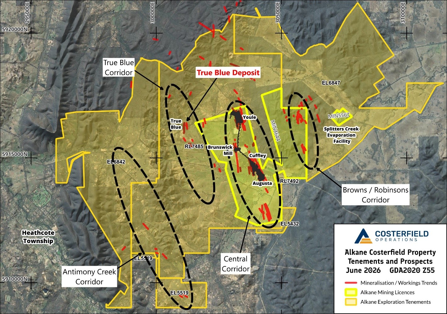
Regional map of the Costerfield Project in GDA2020 grid showing Alkane tenements and the main corridors of mineralisation identified, highlighting the location of the True Blue deposit.

Figure 1. Regional map of the Costerfield Project in GDA2020 grid showing Alkane tenements and the main corridors of mineralisation identified, highlighting the location of the True Blue deposit.

Deposit Geology

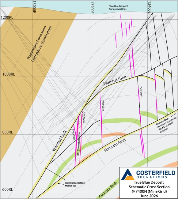
True Blue is located on the western flank of the Costerfield Dome, hosted by Silurian marine siltstones of the Costerfield Formation which correlate via marker beds to the same stratigraphic level as the Youle, Brunswick and Augusta deposits. The siltstone is extensively thickened by duplex ramping into a doubly plunging antiformal thrust stack or dome, within which the bulk of observed mineralisation sits. The main mineralised structures are situated within the western limb of the dome, but many other parallel vertical shears with varying degrees of mineralisation are found closer to the hinge and on the eastern limb. The dominant mineralised structure identified at True Blue has been named the Freeman Vein, and is assigned the Costerfield resource code of 700. Other modelled veins within the deposit include the 702 and 705, which lie close by east and west of the Freeman vein respectively (Figure 2), and the 710 and 720 which occur parallel further east.

The cap of the target veins is well defined by the Wombat Fault, which is strongly lithologically controlled and runs along a ~50cm thick isolated sandstone bed that appears to have acted as the main detachment plane for the thrust stack. The fault is observed in the same stratigraphic position over the entire dome. Lower tenor mineralisation, including the surficial True Blue prospect, occurs above the fault somewhat offset to the east from the Freeman veining.

The footwall boundary of the target system is also well understood. The large, west-dipping Komodo thrust fault truncates the Freeman veining and the host dome. It is also observed that the fault follows the same distinctive sandstone marker bed in its footwall. The apparent along-plane displacement along the Wombat-Komodo sandstone detachment is thus significant, approaching at least 1,000m if restored to its original planar and horizontal position. Mineralisation of moderate tenor has been observed in drilling below the Komodo Fault in an offset position and remains a target for further testing.

Mineralisation at the north and south boundaries of the current resource is of lower grade, which appears to correlate with the increasing plunge of the host dome stratigraphy and bedded structures at the extremities. This observation is in line with other mined Costerfield deposits and reinforces Alkane’s plan to locate and target further dome repetitions along strike in the future.

The current round of infill drilling has resolved the Freeman vein into a sheeted series of vertical north-south veins, generally single-generation fracture fill quartz-stibnite similar in nature to the Kendal deposit at Costerfield as opposed to shear-hosted mineralisation such as found at Brunswick/Cuffley. Mineralised linking structures cross between primary veins at oblique angles. Bedding parallel and subparallel laminated quartz veins and faults also intersect the veins, creating local grade boundaries and complex splay vein arrays. These factors combine to introduce localised complexity (and upside potential) into the system which is otherwise remarkably planar at the deposit scale.

Geological cross section of the True Blue gold-antimony vein system at mine northing 7400N, showing the Freeman vein and associated mineralisation positions relative to the True Blue antiformal dome, and its relationship with known bounding and crosscutting faults. n.b. All traces of new drillholes intersecting the Freeman Vein are illustrated, some appear to not intersect due to the off section effect of the lode system striking ~30 degrees east of mine grid north (see plan section).

Figure 2. Geological cross section of the True Blue gold-antimony vein system at mine northing 7400N, showing the Freeman vein and associated mineralisation positions relative to the True Blue antiformal dome, and its relationship with known bounding and crosscutting faults. n.b. All traces of new drillholes intersecting the Freeman Vein are illustrated, some appear to not intersect due to the off section effect of the lode system striking ~30 degrees east of mine grid north (see plan section).

Drilling Results

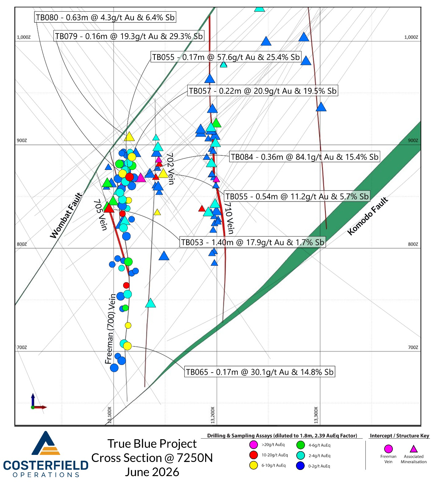
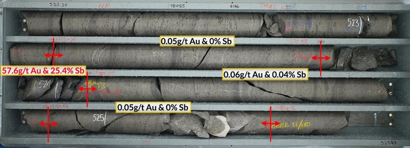
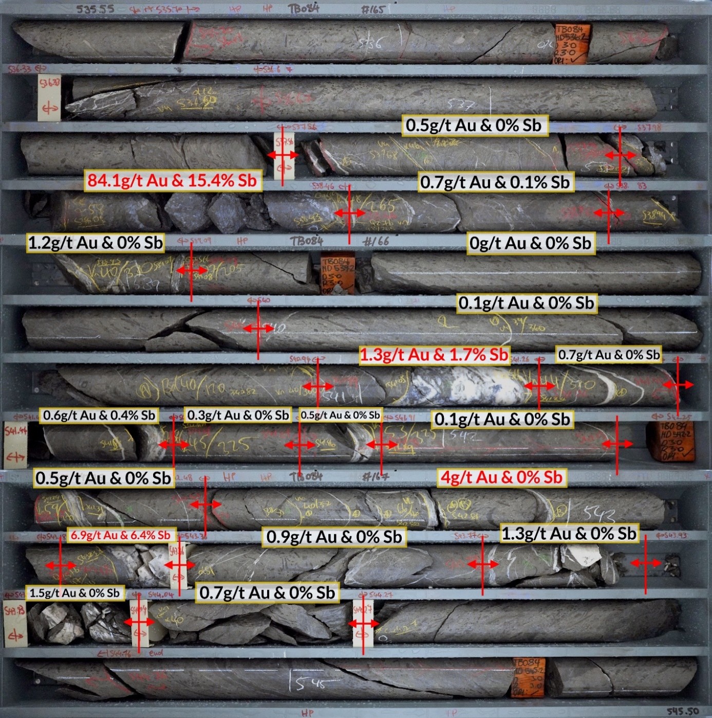
Since the previous release (refer to the Costerfield Resources and Reserves Statement FY25 released on the ASX and TSX on 15 October 2025), 33 growth and infill holes have been completed, totalling 19,012m of diamond drill core. The recent drilling has been concentrated on infilling the upper portion of the Freeman vein and refining structural information to build confidence in the geological model. The deposit from approximately 800RL down to the Komodo Fault footwall contact remains relatively sparsely infilled. Several ore-grade intercepts were made on the Freeman vein, the best of which was from drillhole TB055 (Figure 6) which resulted in 57.6g/t gold and 25.4% antimony over 0.25m (ETW 0.17m). The latest hole drilled into the deposit, TB084, intersected a wide zone of veining (Figure 7) that contained high grade gold and antimony, interpreted to represent a linking zone between the 702 and 705 veins. The best interval within this zone graded 84.1g/t gold and 15.4% antimony over 0.48m (ETW 0.36m).

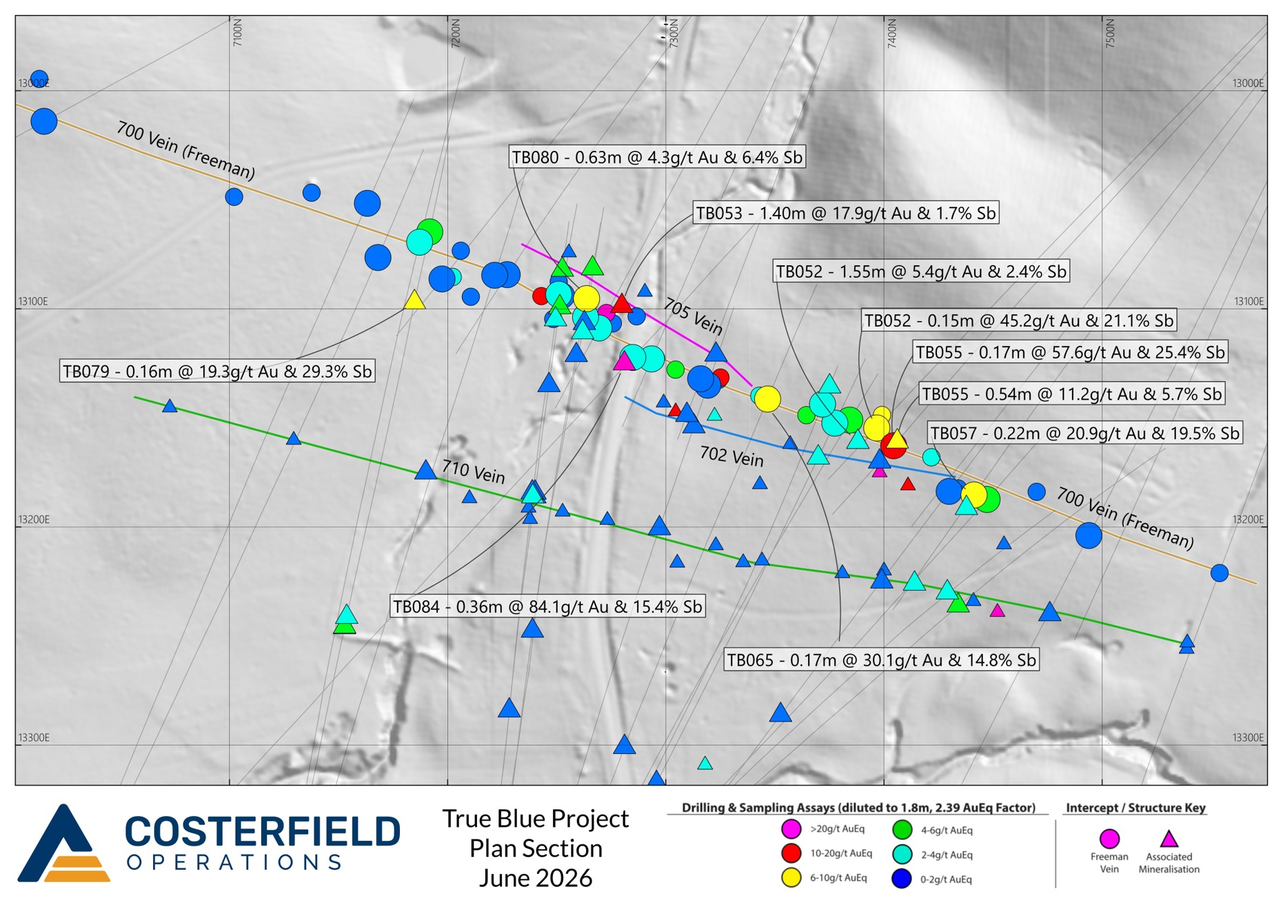
True Blue Deposit Plan Section with major True Blue vein best fit traces displayed, recent drill traces and labels for new intercepts of > 6g/t AuEq when diluted over 1.8m. Older significant drill intercepts are displayed as smaller, unlabelled icons.

Figure 3. True Blue Deposit Plan Section with major True Blue vein best fit traces displayed, recent drill traces and labels for new intercepts of > 6g/t AuEq when diluted over 1.8m. Older significant drill intercepts are displayed as smaller, unlabelled icons.

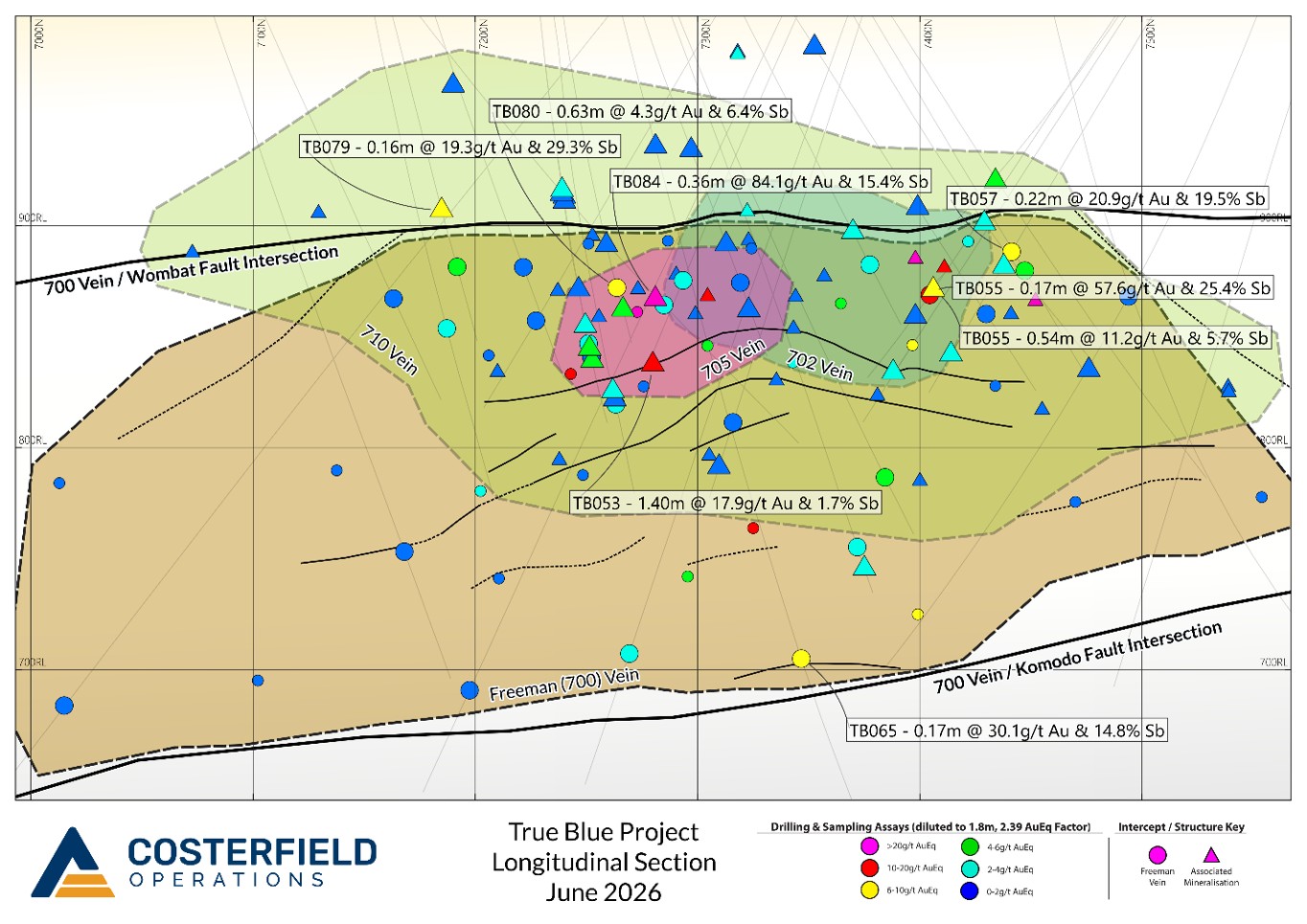
Long Section True Blue deposit with major vein target envelopes displayed, recent drill traces and labels for new intercepts of > 6g/t AuEq when diluted over 1.8m. Older significant drill intercepts are displayed as smaller, unlabelled icons.

Figure 4. Long Section True Blue deposit with major vein target envelopes displayed, recent drill traces and labels for new intercepts of > 6g/t AuEq when diluted over 1.8m. Older significant drill intercepts are displayed as smaller, unlabelled icons.

Schematic Cross section looking north at mine northing 7250N showing True Blue veins and > 6g/t AuEq new intercepts labelled. Older significant drill intercepts are displayed as smaller, unlabelled icons. Intercept eastings have been adjusted to cluster around their assigned veins at this northing to combat off-section effect over the length of the deposit.

Figure 5. Schematic Cross section looking north at mine northing 7250N showing True Blue veins and > 6g/t AuEq new intercepts labelled. Older significant drill intercepts are displayed as smaller, unlabelled icons. Intercept eastings have been adjusted to cluster around their assigned veins at this northing to combat off-section effect over the length of the deposit.

Core tray photo of the Freeman vein intercept described in this announcement, 57.6g/t gold and 25.4% antimony over 0.25m (ETW 0.20m) in drillhole TB055.  The intercept is stibnite-rich with only minor quartz while still carrying significant gold, a common characteristic of the Freeman vein.

Figure 6. Core tray photo of the Freeman vein intercept described in this announcement, 57.6g/t gold and 25.4% antimony over 0.25m (ETW 0.20m) in drillhole TB055. The intercept is stibnite-rich with only minor quartz while still carrying significant gold, a common characteristic of the Freeman vein.

Core tray photograph of the Freeman-702 vein splay zone intersected in TB084, where the highest grade interval of the drill program was intersected.

Figure 7. Core tray photograph of the Freeman-702 vein splay zone intersected in TB084, where the highest grade interval of the drill program was intersected.

Future Plans

Going into FY26-27, continued drilling at True Blue will focus on testing along strike to identify additional deposits. Nearby prospectivity is apparent in several directions from the current resource:

  • North – Soil sampling indicates the True Blue geochemical anomaly may persist at least several hundred metres further north than the current edge of the Freeman resource. At surface approximately 200m north of the resource, outcrops a shear that hosts an albitised and silicified felsic dyke that is strongly anomalous in antimony with pXRF analysis, further evidence indicating persistence of the mineralised system northward from the tested area.
  • South – Diamond drillhole TB022 in early 2024 intersected a wide zone of gold-antimony mineralisation approximately 550m south of the current resource boundary. This zone included 2.6g/t gold over 2.38m (2.00m ETW) (Refer to 28 January 2025 TSX Announcement - Mandalay Intercepts 578 g/t Gold and 20% Antimony over 0.47 Metres at True Blue) Geological interpretation of the drill data suggests that this area may host a repetition of the domal structure that appears to have been important for developing economic mineralisat Freeman and is a high priority for further testing.
  • Depth – The footwall of the Freeman vein system is defined by the regional-scale Komodo thrust fault. Tails of several diamond drillholes at True Blue have encountered vertical mineralised veins below this fault, including veins drilled in hole TB037 discussed in the previous release (Refer to TSX Announcement - 21 July 2025 - Mandalay Extends High-Grade True Blue Discovery. The veins in the Sub-Komodo domain have not been explicitly targeted to date and has high potential for hosting a large mineralised system.
  • East – The West Costerfield prospect sits approximately 800m east of the True Blue deposit and shares a potential ore fluid pathway – the Komodo Fault. At West Costerfield, the fault is much closer to surface, and exhibits localised intense hydrothermal brecciation. The structural environment below the Komodo Fault has not been drill tested away from True Blue, and as the depth prospectivity at True Blue demonstrates is likely to host mineralised veins that are offset from the surface deposit at West Costerfield.

The exploration targets described herein are conceptual in nature. There has been insufficient exploration to define a mineral resource in these areas and it is uncertain if further exploration will result in the delineation of a mineral resource.

An updated True Blue resource will be announced as part of Alkane’s upcoming Resource and Reserves Statement.

This document has been authorised for release to the market by Nic Earner, Managing Director and CEO.

ABOUT ALKANE ‐ www.alkres.com ‐ ASX:ALK | TSX: ALK | OTCQX: ALKRY

Alkane (ASX:ALK; TSX:ALK; OTCQX:ALKRY) is an Australia-based gold and antimony producer with a portfolio of three operating mines across Australia and Sweden. The Company has a strong balance sheet and is positioned for further growth.

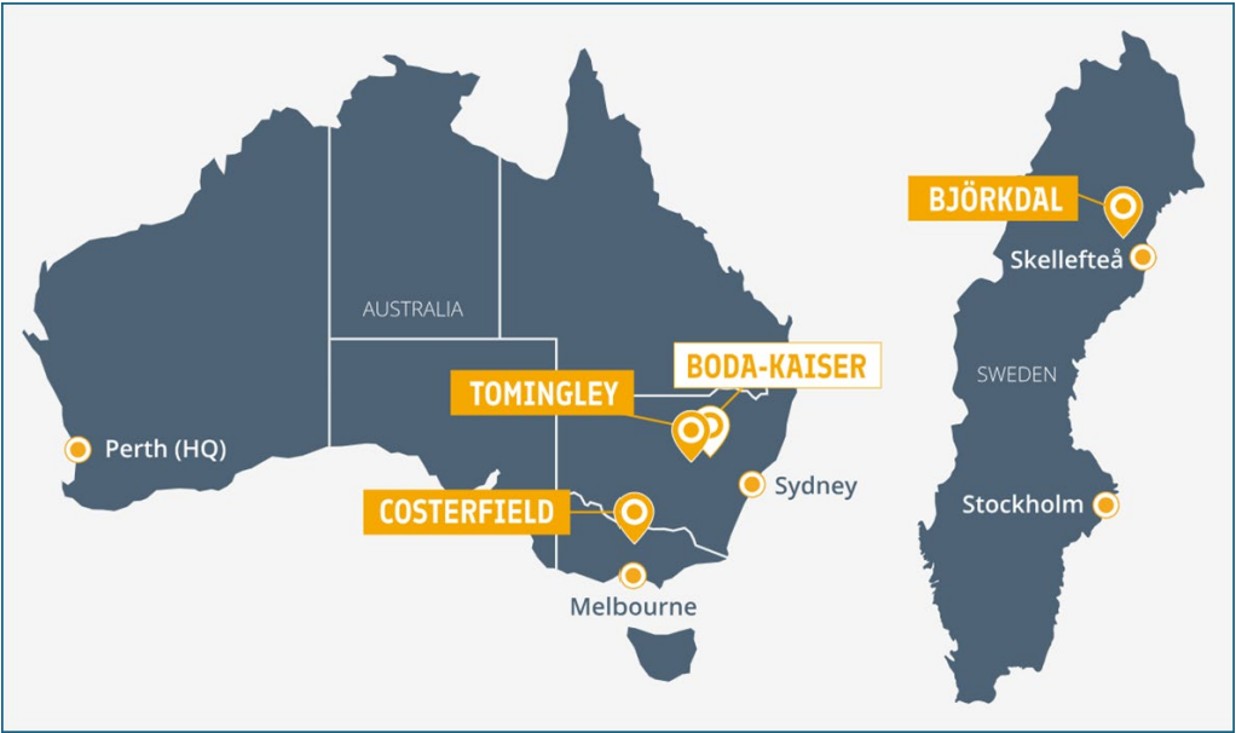
Alkane’s wholly owned producing assets are the Tomingley open pit and underground gold mine southwest of Dubbo in Central West New South Wales, the Costerfield gold and antimony underground mining operation northeast of Heathcote in Central Victoria, and the Björkdal underground gold mine northwest of Skellefteå in Sweden (approximately 750 km north of Stockholm). Ongoing near-mine regional exploration continues to grow resources at all three operations.

Alkane also owns the very large gold-copper porphyry Boda-Kaiser Project in Central West New South Wales and has outlined an economic development pathway in a Scoping Study. The Company has ongoing exploration within the surrounding Northern Molong Porphyry Project and is confident of further enhancing eastern Australia’s reputation as a significant gold, copper and antimony production region.

Alkane Resources Limited

Competent / Qualified Persons Statement

Certain information in this announcement relating to Exploration Results has been previously released to the ASX. Alkane confirms that it is not aware of any new information or data that materially affects the information included in those market announcements and that all material assumptions and technical parameters underpinning the estimates and Exploration Results in those announcements continue to apply and have not materially changed.

The information in this report that relates to the Costerfield Exploration Results is based on, and fairly represents, information compiled and verified by Mr Chris Davis. Mr Davis is a Chartered Professional (Geology) of the Australasian Institute of Mining and Metallurgy (MAusIMM CP(Geo)) and a Member of the Australian Institute of Geoscientists (MAIG).

Mr Davis has sufficient experience that is relevant to the style of mineralisation and type of deposit under consideration and to the activity being undertaken to qualify as a Competent Person as defined in the 2012 Edition of the “Australian Code for Reporting of Exploration Results, Mineral Resources, and Ore Reserves” (JORC Code).

For the purposes of National Instrument 43-101 – Standards of Disclosure for Mineral Projects (‘NI 43-101’), the scientific and technical information contained in this announcement relating to the Costerfield Exploration Results has been prepared under the supervision of, and approved by, Mr Chris Davis, who is a “qualified person” as defined in NI 43-101. Mr Davis is employed by Alkane as Chief Geologist and, as an employee of Alkane, is not considered independent of Alkane within the meaning of NI 43-101.

Mr Davis consents to the inclusion in this report of the matters based on his information in the form and context in which they appear.

Cautionary Note Regarding Forward-Looking Information and Statements

This announcement contains certain forward-looking information and forward-looking statements within the meaning of applicable securities legislation and may include future-oriented financial information or financial outlook information (collectively Forward-Looking Information). Actual results and outcomes may vary materially from the amounts set out in any Forward-Looking Information. As well, Forward-Looking Information may relate to: future outlook and anticipated events; expectations regarding exploration potential; production capabilities and future financial or operating performance, including AISC, investment returns, margins and share price performance; production and cost guidance and the timing thereof; issuing updated resources and reserves estimate and the timing thereof; the potential of Alkane to meet industry targets, public profile and expectations; and future plans, projections, objectives, estimates and forecasts and the timing related thereto.

Forward-Looking Information is generally identified by the use of words like "will", "create", "enhance", "improve", "potential", "expect", "upside", "growth" and similar expressions and phrases or statements that certain actions, events or results "may", "could", or "should", or the negative connotation of such terms, are intended to identify Forward-Looking Information.

Although Alkane believes that the expectations reflected in the Forward-Looking Information are reasonable, undue reliance should not be placed on Forward-Looking Information since no assurance can be provided that such expectations will prove to be correct. Forward-Looking Information is based on information available at the time those statements are made and/or good faith belief of the officers and directors of Alkane as of that time with respect to future events and are subject to risks and uncertainties that could cause actual results to differ materially from those expressed in or suggested by the Forward-Looking Information. Forward-Looking Information involves numerous risks and uncertainties. Such factors include, without limitation: risks relating to changes in the gold and antimony price.

Forward-Looking Information is designed to help readers understand Alkane’s views as of that time with respect to future events and speak only as of the date they are made. Except as required by applicable law, Alkane assumes no obligation to update or to publicly announce the results of any change to any forward-looking statement contained or incorporated by reference herein to reflect actual results, future events or developments, changes in assumptions or changes in other factors affecting the Forward-looking Information. If Alkane updates any one or more forward-looking statements, no inference should be drawn that the company will make additional updates with respect to those or other Forward-looking Information. All Forward-Looking Information contained in this announcement is expressly qualified in its entirety by this cautionary statement.

Disclaimer

Alkane has prepared this announcement based on information available to it. No representation or warranty, express or implied, is made as to the fairness, accuracy, completeness or correctness of the information, opinions or conclusions contained in this announcement. To the maximum extent permitted by law, none of Alkane, its directors, officers, employees, associates, advisers and agents, nor any other person accepts any liability, including, without limitation, any liability arising from fault or negligence on the part of any of them or any other person, for any loss arising from the use of this announcement or its contents or otherwise arising in connection with it.

This announcement is not an offer, invitation, solicitation, or other recommendation with respect to the subscription for, purchase or sale of any security, and neither this announcement nor anything in it shall form the basis of any contract or commitment whatsoever.

APPENDIX 1 – Tabulated Drilling Results

Significant intercepts from the True Blue infill drilling program at Costerfield


Drill hole collar details from True Blue drilling at Costerfield:

Notes:

  1. Coordinate System: Costerfield Local Mine Grid

Appendix 2 - JORC Code, 2012 Edition – Table 1

Section 1 Sampling Techniques and Data

  • Nature and quality of sampling (e.g. cut channels, random chips, or specific specialised industry standard measurement tools appropriate to the minerals under investigation, such as down hole gamma sondes, or handheld XRF instruments, etc.). These examples should not be taken as limiting the broad meaning of sampling.
  • Include reference to measures taken to ensure sample representivity and the appropriate calibration of any measurement tools or systems used.
  • Aspects of the determination of mineralisation that are Material to the Public Report.
  • In cases where ‘industry standard’ work has been done this would be relatively simple (e.g. ‘reverse circulation drilling was used to obtain 1 m samples from which 3 kg was pulverised to produce a 30 g charge for fire assay’). In other cases more explanation may be required, such as where there is coarse gold that has inherent sampling problems. Unusual commodities or mineralisation types (e.g. submarine nodules) may warrant disclosure of detailed information.
  • All stibnite-bearing veins are sampled.
  • Intersections of polyphase breccias, stockwork veins, laminated quartz veins or massive quartz veins were routinely sampled.
  • A waste sample is taken either side of the mineralized vein (30–100 cm).
  • Siltstone is sampled where disseminated arsenopyrite is prevalent.
  • Fault gouge zones were sampled at the discretion of the geologist.
  • Gold grades were determined by either fire assay (25 g charge) with an AAS finish, screen fire assay or Chrysos photon assay technology.
  • Antimony concentrations were determined using an aqua regia based acid digest with an AAS finish.
  • Drill type (e.g. core, reverse circulation, open-hole hammer, rotary air blast, auger, Bangka, sonic, etc) and details (e.g. core diameter, triple or standard tube, depth of diamond tails, face-sampling bit or other type, whether core is oriented and if so, by what method, etc.).
  • Method of recording and assessing core and chip sample recoveries and results assessed.
  • Measures taken to maximise sample recovery and ensure representative nature of the samples.
  • Whether a relationship exists between sample recovery and grade and whether sample bias may have occurred due to preferential loss/gain of fine/coarse material.
  • Whether core and chip samples have been geologically and geotechnically logged to a level of detail to support appropriate Mineral Resource estimation, mining studies and metallurgical studies.
  • Whether logging is qualitative or quantitative in nature. Core (or costean, channel, etc.) photography.
  • The total length and percentage of the relevant intersections logged.
  • If core, whether cut or sawn and whether quarter, half or all core taken.
  • If non-core, whether riffled, tube sampled, rotary split, etc., and whether sampled wet or dry.
  • For all sample types, the nature, quality and appropriateness of the sample preparation technique.
  • Quality control procedures adopted for all sub-sampling stages to maximise representivity of samples.
  • Measures taken to ensure that the sampling is representative of the in situ material collected, including for instance results for field duplicate/second-half sampling.
  • Whether sample sizes are appropriate to the grain size of the material being sampled.
  • Sample information and characteristics were measured, logged, recorded in the acQuire database and assigned a unique sample ID.
  • Sample material was placed into a calico bag previously marked with the unique sample ID.
  • Calico bags were loaded into plastic bags such that the plastic bags weighed less than 10 kg.
  • An assay submission sheet was generated and placed into the plastic bag.
  • Plastic bags containing samples were sealed with a metal or plastic tie and transported to On Site in Bendigo via private courier or Alkane staff.
  • Samples were received and checked for labelling, missing samples, etc. against the submission sheet.
  • If the sample batch matched the submission sheet, sample metadata were entered into On Site’s LIMS. In the event that discrepancies were noted, Mandalay Resources was contacted by On Site to resolve the discrepancy prior to further work commencing. Records of all discrepancies and corrective actions taken are recorded by the Mandalay Resources database administrator.
  • A job number was assigned, and worksheets and sample bags were prepared.
  • Samples were placed in an oven and dried overnight at 106°C.
  • Samples were weighed and recorded.
  • The entire dried sample was crushed using a Rocklabs Smart BOYD Crusher RSD Combo with a jaw closed side setting of 2 mm.
  • If the dried sample weight was less than 3 kg, the entire sample was retained for pulverisation. If the dried sample weight was greater than 3 kg, the sample was spilt to 3 kg using the rotary splitter that is incorporated in the BOYD crusher.
  • Rejects from splits greater than 3 kg were retained as coarse rejects in labelled calico bags and returned to Mandalay Resources.
  • The 3 kg sample was then pulverised in an Essa LM5 Pulverising Mill to 90% passing 75 µm.
  • The 3 kg pulverised samples were then subsampled to take a master ~200 g pulp split for assay by a manual scooping procedure across the full width and depth of the mill bowl and loaded sequentially into labelled pulp packets.
  • The ~3 kg pulverised samples were then subsampled to fill a ~280 g photon assay jar by a manual scooping procedure across the full width and depth of the mill bowl.
  • For every 21 primary samples, a sample was randomly selected by LIMS and a duplicate 200 g split for fire assay or second jar for photon assay was submitted for analysis using the same analytical procedure as the primary sample.
  • The remaining pulp was returned to its sample bag and then returned to Mandalay Resources for retention following the completion of assay.
  • The nature, quality and appropriateness of the assaying and laboratory procedures used and whether the technique is considered partial or total.
  • For geophysical tools, spectrometers, handheld XRF instruments, etc., the parameters used in determining the analysis including instrument make and model, reading times, calibrations factors applied and their derivation, etc.
  • Nature of quality control procedures adopted (e.g. standards, blanks, duplicates, external laboratory checks) and whether acceptable levels of accuracy (i.e. lack of bias) and precision have been established.
  • Gold grades were determined either by a 25g charge with lead flux fire assay and an AAS finish, or by Chrysos photon assay technology.
  • Antimony, iron and arsenic concentrations were determined using an aqua regia based acid digest with an AAS finish.
  • The verification of significant intersections by either independent or alternative company personnel.
  • The use of twinned holes.
  • Documentation of primary data, data entry procedures, data verification, data storage (physical and electronic) protocols.
  • Discuss any adjustment to assay data.
  • Accuracy and quality of surveys used to locate drill holes (collar and downhole surveys), trenches, mine workings and other locations used in Mineral Resource estimation.
  • Specification of the grid system used.
  • Quality and adequacy of topographic control.
  • Data spacing for reporting of Exploration Results.
  • Whether the data spacing and distribution is sufficient to establish the degree of geological and grade continuity appropriate for the Mineral Resource and Ore Reserve estimation procedure(s) and classifications applied.
  • Whether sample compositing has been applied.
  • Whether the orientation of sampling achieves unbiased sampling of possible structures and the extent to which this is known, considering the deposit type.
  • If the relationship between the drilling orientation and the orientation of key mineralised structures is considered to have introduced a sampling bias, this should be assessed and reported if material.
  • The measures taken to ensure sample security.
  • The results of any audits or reviews of sampling techniques and data.


Section 2 Reporting of Exploration Results
Criteria listed in the Section 1 also apply to this section.

  • Type, reference name/number, location and ownership including agreements or material issues with third parties such as joint ventures, partnerships, overriding royalties, native title interests, historical sites, wilderness or national park and environmental settings.
  • The security of the tenure held at the time of reporting along with any known impediments to obtaining a licence to operate in the area.
  • Acknowledgment and appraisal of exploration by other parties.
  • Deposit type, geological setting and style of mineralisation.
  • A summary of all information material to the understanding of the exploration results including a tabulation of the following information for all Material drill holes:
    • easting and northing of the drill hole collar
    • elevation or RL (Reduced Level – elevation above sea level in metres) of the drill hole collar
    • dip and azimuth of the hole
    • downhole length and interception depth
    • hole length.
  • If the exclusion of this information is justified on the basis that the information is not Material and this exclusion does not detract from the understanding of the report, the Competent Person should clearly explain why this is the case.
  • In reporting Exploration Results, weighting averaging techniques, maximum and/or minimum grade truncations (e.g. cutting of high grades) and cut-off grades are usually Material and should be stated.
  • Where aggregate intercepts incorporate short lengths of high grade results and longer lengths of low grade results, the procedure used for such aggregation should be stated and some typical examples of such aggregations should be shown in detail.
  • The assumptions used for any reporting of metal equivalent values should be clearly stated.
  • at a gold price of US$2,500/oz
  • an antimony price of US$19,000/t
  • with 2025 predicted metal recoveries of 91% Au and 92% Sb.
  • These relationships are particularly important in the reporting of Exploration Results.
  • If the geometry of the mineralisation with respect to the drill hole angle is known, its nature should be reported.
  • If it is not known and only the down hole lengths are reported, there should be a clear statement to this effect (e.g. ‘downhole length, true width not known’).
  • Appropriate maps and sections (with scales) and tabulations of intercepts should be included for any significant discovery being reported These should include, but not be limited to a plan view of drill hole collar locations and appropriate sectional views.
  • Where comprehensive reporting of all Exploration Results is not practicable, representative reporting of both low and high grades and/or widths should be practiced to avoid misleading reporting of Exploration Results.
  • Other exploration data, if meaningful and material, should be reported including (but not limited to): geological observations; geophysical survey results; geochemical survey results; bulk samples – size and method of treatment; metallurgical test results; bulk density, groundwater, geotechnical and rock characteristics; potential deleterious or contaminating substances.
  • If (Sb%>1) BD=((1.3951 × Sb%)+(100-(1.3951 × Sb%)))/(((1.3951 × Sb%)/4.56)+((100-(1.3951 × Sb%))/2.69) )
  • If (Sb%<1) BD= (0.05661 × Fe%) + 2.5259
  • where:
  • Empirical formula of stibnite: Sb2S3.
  • Sb%: Antimony assay as a percentage by mass.
  • Molecular weight of antimony (Sb): 121.757.
  • Molecular weight of sulfur: (S): 32.066.
  • 1.3951 is a constant calculated by 339.712/243.514 where 339.712 is the molar mass of Sb2S3, and 243.514 is the molar mass of antimony contained in one mole of pure stibnite.
  • BD of pure stibnite: 4.56.
  • BD of unmineralised gangue: 2.69, representing a ratio of 1:3 siltstone to quartz.
  • Fe%: Iron assay as a percentage by mass.
  • The nature and scale of planned further work (e.g. tests for lateral extensions or depth extensions or large-scale step-out drilling).
  • Diagrams clearly highlighting the areas of possible extensions, including the main geological interpretations and future drilling areas, provided this information is not commercially sensitive.


CONTACT: 
NIC EARNER, MANAGING DIRECTOR & CEO, ALKANE RESOURCES LTD, TEL +61 8 9227 5677

INVESTORS & MEDIA:  NATALIE CHAPMAN, CORPORATE COMMUNICATIONS MANAGER, TEL +61 418 642 556

Photos accompanying this announcement are available at:
https://www.globenewswire.com/NewsRoom/AttachmentNg/09d9986d-a65e-4c18-9c23-da587dd51f4b
https://www.globenewswire.com/NewsRoom/AttachmentNg/585ded94-3796-4d0f-b3e3-7b71cc0042fd
https://www.globenewswire.com/NewsRoom/AttachmentNg/c86e485c-e857-4bb6-afa9-5fbb6c7cb70e
https://www.globenewswire.com/NewsRoom/AttachmentNg/9ad3d698-2316-4e9e-9703-bf7433f1df8c
https://www.globenewswire.com/NewsRoom/AttachmentNg/c49e6740-5a1d-4885-a871-f4e53449abb4
https://www.globenewswire.com/NewsRoom/AttachmentNg/77963b96-fb54-4b8c-af45-1af0cd35af35
https://www.globenewswire.com/NewsRoom/AttachmentNg/ed47cff1-a203-49d7-98a4-85bebdce27d5
https://www.globenewswire.com/NewsRoom/AttachmentNg/a8e92999-4fc4-434f-b42c-2c567fa218e7


Dein Kommentar zum Artikel im Forum

Jetzt anmelden und diskutieren Registrieren Login

Hinweis: ARIVA.DE veröffentlicht in dieser Rubrik Analysen, Kolumnen und Nachrichten aus verschiedenen Quellen. Die ARIVA.DE AG ist nicht verantwortlich für Inhalte, die erkennbar von Dritten in den „News“-Bereich dieser Webseite eingestellt worden sind, und macht sich diese nicht zu Eigen. Diese Inhalte sind insbesondere durch eine entsprechende „von“-Kennzeichnung unterhalb der Artikelüberschrift und/oder durch den Link „Um den vollständigen Artikel zu lesen, klicken Sie bitte hier.“ erkennbar; verantwortlich für diese Inhalte ist allein der genannte Dritte.


Themen im Trend